Feb 8, 2018 - Makȟóčhe Wašté: The Beautiful Country A Lakȟóta Landscape Map by Dakota Wind
Bismarck, ND (TFS) – Sometime in 1932 Cottonwood, Takes His Shield, an Iháŋkthuŋwaŋna, or “Yanktonai,” which is a division of the Očhéthi Šakówiŋ (Seven Council Fires; “Great Sioux Nation) sat down with Cottonwood (Iháŋkthuŋwaŋna), a traditional artist, who listened and composed a map testimony of the 1863 Whitestone Hill Massacre.
At first glance, the map’s “action” details the approach of General Alfred Sully’s command from the southwest. By Sully’s account, he approached Whitestone Hill from the northwest. If one rotates the map to correct the action so that Sully’s approach matches Sully’s account, other events on the map become reversed. If one mirrors the map, the map seems to still be incorrect.
A map of the 1863 Whitestone Hill Massacre. For an interpretation of the events on the map visit the Whitestone Hill page at ND Studies. Note: south is at the top.

The Takes His Shield map testimony, composed by Cottonwood, were simply taken as it is, it is in fact correct. One needs to change one’s world view orientation, so that the top of the page is south, the bottom of the page is north; left is east, and right is west. It is clear that Takes His Shield and Cottonwood were right all along and that Sully’s command does indeed approach them from the northwest. There is no need to manipulate the image.
Years after the spectacular failure of Lt. Col. Custer’s campaign at the Little Bighorn conflict, survivors composed their own map testimonies of the fight. There are several, including one attributed to Sitting Bull though it appears to have been drafted by a military hand. Here are a few excerpts of Húŋkpapȟa maps previewed from Mike Donahue’s amazing “Drawing Battle Lines.” Check your local library, or order yourself a copy.
A Húŋkpapȟa map of the Little Bighorn conflict.

Little Soldier, a Húŋkpapȟa, drew this map of the Little Bighorn conflict.

This map of the Little Bighorn conflict is attributed to Rain In The Face. The notations in English were made by someone else.

A southern oriented world view perspective is represented in the Húŋkpapȟa maps. It is interesting to note that the Húŋkpapȟa show only the camp divisions, not the actual fight. They all demonstrate that the Húŋkpapȟa camp was the one first attacked when Major Reno came calling in the Month of Ripe Chokecherries.
A few years ago, I composed a paper about the 1863 Sibley punitive campaign into Dakota Territory. I interviewed elders and relatives, and reconstructed the Apple Creek Fight. I included a directional arrow (pointing north; how colonized of me) with text saying “Wazíyata,” or “North.” I used Dakhóta and Lakȟóta place names for the rivers and streams, and plateau. I thought I did good.
My map of the Apple Creek Fight. 2200 soldiers under Sibley’s command against, in his own estimation, 500 warriors on the plateau. It was a conflict bigger than the Little Bighorn. Eventually, I’ll post a south oriented map.

Afterward, a little uŋčí (grandmother) from Sisseton, SD, wondered that I since I had put so much work into my paper and map, why did I refer to our country as “Khéya Wíta,” or “Turtle Island.” Long ago, we called the land, and by extension, “Makȟóčhe Wašté.” I began to do so. If others want to refer to her as Turtle Island, that’s okay. On Makȟóčhe Wašté, Čhetáŋ (Hawk) doesn’t tell Tȟašíyagmuŋka (Western Meadowlark) how to hunt.
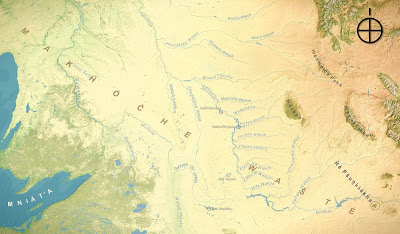
My own map of the waterways on the Northern Great Plains. Note: Edited on Dec. 4, 2017, and again on Dec. 5, 2017. Thank you Decolonial Atlas for getting me started on this map.
The Lakȟóta word for south is: Itókaǧa (Facing-The-Flow-Of-The-Current), or “Facing The Downstream Direction,” or simply, “Facing Downstream.” In any case, it means looking south. The south wind is personified in lore as one of five brothers. In some stories, the cardinal directions are spoken of as giants. In one story, the South grapples with the north for control of the plains, which results in summer when the South wins, and winter when the North wins.
The other directions are important too. Očhéthi Šakówiŋ women set up their lodges facing east. When singers begin the Four Directions Song (sometimes Six Directions) they begin facing the west. The fifth and sixth directions are the sky above and the world we live on. There’s also a story of the Seventh Direction, which is the heart.
This brings me to my Lakȟóta map project: Makȟóčhe Wašté, The Beautiful Country.
A view of Makȟóčhe Wašté. The Očhéthi Šakówiŋ locations are towards the geographical center of the continent.

I’ve constructed an interactive map of the Northern Great Plains using place names taken from winter counts, oral tradition, interviews, maps, and books. Some of these place names do not match contemporary place names. Some place names are known by more than one name. Some streams names are not accompanied by “Wakpá,” meaning “River,” or “Wakpála,” meaning “Creek.” Some lakes are not accompanied by “Mdé/Bdé,” meaning “Lake.” One significant change to the landscape, from contemporary American to Očhéthi Šakówiŋ cultural, is that it is the Ȟaȟáwakpa (Mississippi River) that converges with Mníšoše (the Missouri River). Thinking of it this way, seeing it this way, then it is the mouth of the Mníšoše which drains into the Gulf of Mexico.
This map is not complete. If you would like to share a place name with me, I’d be happy to add it and attribute you and your sources.
Here’s my Google Map. It’s not south oriented, so bear with me.
I’m not saying I’m right. I’m just sharing as it appears to me. Please share this, and let me know what you think. Philámaya pó.
Dakota Wind is an enrolled member of the Standing Rock Sioux Tribe. He is a student at North Dakota State University in Fargo, working on a graduate degree in history. Dakota has written for various journals and magazines, and a recent paper of his appears in Karl Skarstein’s “The War With The Sioux,” 2015, for a free e-copy visit The Digital Press. He occasionally maintains the history blog The First Scout.